

Drainage and plumbing, Riley Park
Drainage and Plumbing in Riley Park, Vancouver
Riley Park runs from E 16th Avenue south to E 41st, Cambie Street across to Fraser Street. The summit of Little Mountain inside Queen Elizabeth Park is the highest ground in the City’s own elevation data.
That makes this the one neighbourhood we work where water leaves rather than collects. We camera the line before anybody quotes a number, and the footage is yours.
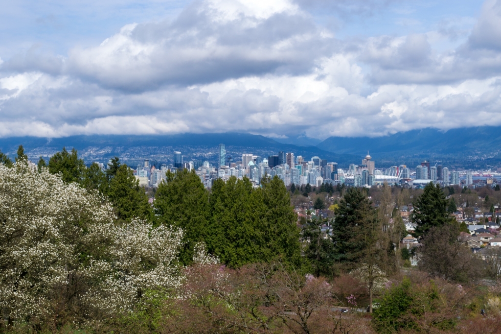
This is the top of Vancouver, and water leaves it
The 125 metre contour is the single highest value in the City’s entire one metre contour dataset, and all eight segments carrying it sit inside Queen Elizabeth Park. Little Mountain is a basalt outcrop formed between 31 and 34 million years ago, quarried by the CPR for road rock from 1890 to 1911, and one of those quarries became a city water reservoir in the 1920s before a parking lot went over it in 1963.
Inside the same neighbourhood the ground falls to 46 metres at the northeast corner, near Fraser Street between about E 16th and E 18th. That is roughly 79 metres of fall across about a kilometre and a half, all within one local area. It means the drainage question changes depending which flank you are on. On the upper slope runoff does not sit, it moves. At the bottom it arrives with speed behind it. The City’s own 3-1-1 street flooding reports line up with that: 118 of Riley Park’s 339 street flooding cases, 34.8%, fall in that low northeast quadrant.
What is under the road is old regardless of the flank. Of 105.3 kilometres of City sewer main here, 36.19 kilometres is still combined, one pipe carrying rain and sewage together. That is 34.4% against a city figure of 27.9%. And 24.22 kilometres of that combined main is vitrified clay.
The counter-intuitive part is where the combined pipe concentrates. The southwest quadrant, Cambie to Main between about E 28th and E 41st, has a median house build year of 1980 and the highest combined share of the four quadrants at 40.0%. New houses, oldest style of street sewer.
Signs worth putting a camera on
Riley Park has logged more than a thousand sewer backup calls to the City’s 3-1-1 line across the two published datasets, and the monthly peaks are October, November and December. These are the openers.
- Water on the basement slab after heavy rain, in the same corner every time
- Slow drains on more than one fixture at once
- The toilet gurgles when the washer or a sink drains
- A sewer smell in the basement or in a lower suite
- A lower floor fixture that backs up when it rains but not otherwise
- Standing water in the yard over the line of the perimeter drain
- Water arriving fast at the low side of the lot rather than pooling evenly

The houses here are older than people think
Riley Park gets described as a bungalow and Vancouver Special neighbourhood. The assessment roll says otherwise. Across 4,978 detached and duplex parcels with a build year, the 1940s, 1950s and 1960s together are 21.1%. The 1910s alone are 20.7%. 35.7% of the stock predates 1940 and 47.3% predates 1950. Builds from 1965 to 1984, the Vancouver Special era, are 15.1%. Specials are here, they are just not the story.
That age profile is the reason a camera earns its keep here. Nobody publishes what is under an individual house, and we will not pretend otherwise. What is published is that vitrified clay is 41.99 kilometres of the City main under these streets, and that the era most of this housing went up in is the era clay laterals went in with it. The way to know what you have is to look at it.
The Vancouver Special detail that does hold up is architectural rather than statistical. The type is built on grade without a raised foundation, and the front door sits to one side so the lower floor can carry a suite. That puts fixtures below grade, which changes what a partial blockage does to the house.
The City is separating a combined sewer inside this neighbourhood right now. Its East 35th Avenue project, between Main Street and Quebec Street, replaces the existing sewer with a separated higher capacity system, one pipe for rainwater runoff and another for sewage, on a main it describes as having a 100 year service life. That is the abstract 34.4% number turned into a street a reader can walk to.
24/7 emergency dispatch
Drainage problem in Riley Park?
Ryan picks up. Live dispatch, and you get a real arrival window on the call. We camera the line before anybody quotes a number, and you watch the monitor with us.
What Vancouver customers say
Ryan was great! My landlord called him to fix my blocked kitchen sink. He showed up the same day (on a Sunday) and fixed the problem. He even cleaned the sink and dried up all the water that had leaked before he got there. And he was very careful coming in and out of the house so my cat wouldn’t get out. I’d definitely recommend him.
Ryan is INCREDIBLE. He has been responding to all of us (four houses and families!) affected by a sewage back up. This is all on Boxing Day and beyond, in terrible weather full of ice, cold and rain. He is so knowledgeable, and knew what was needed right away. Just the top of his field I am sure. As well as that, he is incredibly calm, respectful, kind and fair. I am truly amazed by this person's capacity and competence in combination with his noble, calm presence in the face of a real mess. Thank you Ryan, so very much!
I had very positive experience with Mamba Services, Ryan was amazing to work with and took care of my drain issues in no time. He arrived on time, was very professional and efficient in carrying out the work. What impressed me was how honest he was in recommending needed repair. He was very patient in explaining the different options. I will certainly call them for future projects.
Had an excellent experience. Ryan was fantastic, it was an after hours call late in the evening and he showed up exactly in the time frame he gave. Took care of the kitchen sink issue within minutes all systems were running like new. Pricing was extremely reasonable, Ryan was patient and explained everything to me while fixing my problem. I would highly recommend this company for any plumbing work.
Ryan was efficient, experienced, and knowledgeable. He was able to squeeze me into his schedule with short notice and wasted no time with my appointment. He arrived on site inspected the issue, and was quickly at work with resolving the problem. I am very pleased with his service and honesty. He provided recommendations that will help assist me in future occurrences.
Riley Park drainage and plumbing FAQ
E 16th Avenue on the north, E 41st Avenue on the south, Cambie Street on the west and Fraser Street on the east. Queen Elizabeth Park sits on the west side, Mountain View Cemetery on the east between 31st and 43rd, and Main Street is the commercial spine through the middle.
There is a decent chance. 36.19 of the 105.3 kilometres of City sewer main here is still combined, 34.4%, which is above the city figure of 27.9%. It is highest in the southwest quadrant between Cambie and Main at 40.0% and lowest in the northeast at 28.3%. We can tell you what is under your block before we come out.
On one street here, yes. The City’s East 35th Avenue project between Main Street and Quebec Street replaces the existing sewer with a separated, higher capacity system, one pipe for rainwater runoff and another for sewage. Nobody has published a schedule for the other streets, so we will not invent one.
More likely than most people assume. 35.7% of the detached and duplex parcels here were built before 1940 and 47.3% before 1950. The 1910s alone are 20.7% of the stock. The 1940s to 1960s bungalow picture people carry around is only 21.1%.
By looking at it. Nobody publishes private side pipe material and we will not guess at it from your build year. What is on record is that vitrified clay accounts for 41.99 kilometres of the City main under these streets. The camera answers the rest, and you watch the monitor with us.
Because of grade. The ground falls about 79 metres from Queen Elizabeth Park to the corner near Fraser and E 16th. Runoff on the upper flank moves rather than sits, and it arrives at the low corner with pace. 118 of the 339 street flooding cases reported here fall in that quadrant.
Not that anybody has been able to source. Brewery Creek and China Creek belong to Mount Pleasant and Kensington. Riley Park sits between 46 and 125 metres on a basalt outcrop, it is not in the designated floodplain, and there is no river silt under it. Its water problem is slope and pipe age.
They are one cause and it is Metro Vancouver’s own wording, not ours. It advises against planting water loving trees or shrubs over a sewer line because the roots can pry open the joints between pipes. Riley Park carries 11,521 City trees, 2,720 of them maples, with 1,012 trunks 75 cm or wider.
Usually because it is the lowest fixture on the line. A house built on grade with a lower floor suite puts its drains below everything else, so a partial blockage further down shows up there first. It is a useful early warning rather than a separate problem.
The real neighbours are Mount Pleasant to the north, Kensington-Cedar Cottage to the east, South Cambie to the west, and Sunset and Oakridge to the south. We work in all of them, plus the rest of Vancouver, Burnaby, New Westminster and the North Shore.
24/7 EMERGENCY DISPATCH
Water where it should not be?
Ryan picks up. Live dispatch, and you get a real arrival window on the call.